Lake Winnipegosis Contents Geography Communities Fisheries See also References Navigation menu52°30′N 100°00′W / 52.500°N 100.000°W / 52.500; -100.00052°30′N 100°00′W / 52.500°N 100.000°W / 52.500; -100.000"The Canadian Encyclopedia (Lake Winnipegosis)""Google Maps Distance Calculator""Manitoba Wildlands (Protected Areas Announcements)""Natural Resources Canada-Canadian Geographical Names (Lake Winnipegosis)""Atlas of Canada Toporama""A profile of Manitoba's commercial fishery"e
Lakes of Manitoba
lakeNorth AmericaManitobaWinnipegLake WinnipegLake ManitobaLake AgassizwatershedManitobaSaskatchewanManitoba EscarpmentCedar LakeWaterhen RiverLake WinnipegNelson RiverHudson BayWaterhen LakeDauphin LakeSwan LakeWinnipegosisCampervillePine CreekDuck BaySalt PointMeadow PortageShoal RiverPelican RapidsDawson BayDenbeigh PointwalleyefreshwaterNorthern pikemullet
Lake Winnipegosis
Jump to navigation
Jump to search
| Lake Winnipegosis | |
|---|---|
 | |
| Location | Manitoba |
| Coordinates | 52°30′N 100°00′W / 52.500°N 100.000°W / 52.500; -100.000Coordinates: 52°30′N 100°00′W / 52.500°N 100.000°W / 52.500; -100.000 |
| Primary outflows | Waterhen River |
| Catchment area | 49,825 km2 (19,238 sq mi)[1] |
Basin countries | Canada |
| Max. length | 195 km (121 mi) |
| Max. width | 51 km (32 mi) |
| Surface area | 5,370 km2 (2,070 sq mi)[1] |
| Max. depth | 12 m (39 ft) |
| Surface elevation | 254 m (833 ft)[1] |
| Settlements | Camperville, Winnipegosis |
Lake Winnipegosis is a large (5,370 km²) lake in central North America, in Manitoba, Canada, some 300 km northwest of Winnipeg. It is Canada's eleventh-largest lake. An alternate spelling, once common but now rare, is Lake Winipigoos or simply 'Lake Winipigis'.
The lake's name derives from that of Lake Winnipeg, with a diminutive suffix. Winnipeg means 'big muddy waters' and Winnipegosis means 'little muddy waters'.[1]
Contents
1 Geography
1.1 Outflows
1.2 Tributaries
2 Communities
3 Fisheries
4 See also
5 References
Geography

NASA image of Lake Winnipegosis
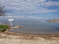
Lake Winnipegosis from Winnipegosis Beach
The elongated, 195 kilometre long lake is the second-largest of three large lakes in central Manitoba; the other two are Lake Winnipeg, the largest, and Lake Manitoba. All three lakes are on the floor of the prehistoric glacial Lake Agassiz. The lake's watershed extends over some 49,825 km² in Manitoba and Saskatchewan. It receives most of its waters from the Manitoba Escarpment.[1]
Lake Winnipegosis is separated from Cedar Lake by a 6 km (3.7 miles) wide (minimum width) land barrier at the north end and from Lake Manitoba by a 3 km (1.9 miles) wide (minimum width) land barrier at the southeast end at Meadow Portage.[2]
Birch Island is the largest island on Lake Winnipegosis. The island, located near the middle of the lake, is part of Birch Island Provincial Park created in 2010 and is adjacent to the Chitek Lake Park Reserve on the eastern shore.[3]
Outflows
The lake drains through the Waterhen River into Lake Manitoba, and is thus part of the Lake Winnipeg, Nelson River, and Hudson Bay watersheds. From Long Island Bay at the southeast end of the lake the West Waterhen and Little Waterhen rivers flow north about 16 km (10 miles) into Waterhen Lake then the Waterhen River flows south 22 km (13.5 miles) into Lake Manitoba.[2]
Tributaries
Tributaries include the Mossy River (from Dauphin Lake), Point River, Pine River, North Duck River, Pelican River (from Pelican Lake), Shoal River (from Swan Lake), Steeprock River, Red Deer River and the Overflowing River.[4][5]
Communities
The communities of Winnipegosis, Camperville, Pine Creek, Duck Bay, Salt Point and Meadow Portage are south of Birch Island while Shoal River, Pelican Rapids, Dawson Bay and Denbeigh Point are to the north of the island.[4]
Fisheries
The lake supports a commercial fishery of walleye and other freshwater species. Northern pike and mullet together now account for over 80 percent of its commercial fishing.[6]
See also
- List of lakes of Manitoba
References
^ abcde "The Canadian Encyclopedia (Lake Winnipegosis)". Retrieved 2014-12-22..mw-parser-output cite.citationfont-style:inherit.mw-parser-output .citation qquotes:"""""""'""'".mw-parser-output .citation .cs1-lock-free abackground:url("//upload.wikimedia.org/wikipedia/commons/thumb/6/65/Lock-green.svg/9px-Lock-green.svg.png")no-repeat;background-position:right .1em center.mw-parser-output .citation .cs1-lock-limited a,.mw-parser-output .citation .cs1-lock-registration abackground:url("//upload.wikimedia.org/wikipedia/commons/thumb/d/d6/Lock-gray-alt-2.svg/9px-Lock-gray-alt-2.svg.png")no-repeat;background-position:right .1em center.mw-parser-output .citation .cs1-lock-subscription abackground:url("//upload.wikimedia.org/wikipedia/commons/thumb/a/aa/Lock-red-alt-2.svg/9px-Lock-red-alt-2.svg.png")no-repeat;background-position:right .1em center.mw-parser-output .cs1-subscription,.mw-parser-output .cs1-registrationcolor:#555.mw-parser-output .cs1-subscription span,.mw-parser-output .cs1-registration spanborder-bottom:1px dotted;cursor:help.mw-parser-output .cs1-ws-icon abackground:url("//upload.wikimedia.org/wikipedia/commons/thumb/4/4c/Wikisource-logo.svg/12px-Wikisource-logo.svg.png")no-repeat;background-position:right .1em center.mw-parser-output code.cs1-codecolor:inherit;background:inherit;border:inherit;padding:inherit.mw-parser-output .cs1-hidden-errordisplay:none;font-size:100%.mw-parser-output .cs1-visible-errorfont-size:100%.mw-parser-output .cs1-maintdisplay:none;color:#33aa33;margin-left:0.3em.mw-parser-output .cs1-subscription,.mw-parser-output .cs1-registration,.mw-parser-output .cs1-formatfont-size:95%.mw-parser-output .cs1-kern-left,.mw-parser-output .cs1-kern-wl-leftpadding-left:0.2em.mw-parser-output .cs1-kern-right,.mw-parser-output .cs1-kern-wl-rightpadding-right:0.2em
^ ab "Google Maps Distance Calculator". Retrieved 2014-12-22.
^ "Manitoba Wildlands (Protected Areas Announcements)". Retrieved 2014-12-28.
^ ab "Natural Resources Canada-Canadian Geographical Names (Lake Winnipegosis)". Retrieved 2014-12-28.
^ "Atlas of Canada Toporama". Retrieved 2014-12-28.
^ "A profile of Manitoba's commercial fishery" (PDF). Manitoba Water Stewardship (Department, Government of Manitoba). 2010-05-14. Retrieved 2011-07-29.
.mw-parser-output .navbox-canada .navbox-title,.mw-parser-output .navbox-canada th,.mw-parser-output .navbox-canada .navbox-group,.mw-parser-output .navbox-canada .navbox-abovebelow,.mw-parser-output .navbox-canada .navbox-subgroup,.mw-parser-output .navbox-canada .navbox-odd,.mw-parser-output .navbox-canada .navbox-evenbackground-color:white.mw-parser-output .navbox-canada .navbox-list .collapsible .navbox-titlebox-shadow:inset 1px 1px 0 #C00,inset -1px -1px 0 #C00.mw-parser-output .navbox-canada-abox-shadow:inset 1px 1px 0 #C00,inset -1px -1px 0 #C00.mw-parser-output .navbox-canada-tbox-shadow:inset 0 1px 0 0 #C00.mw-parser-output .navbox-canada-bbox-shadow:inset 0 -1px 0 0 #C00.mw-parser-output .navbox-canada-tbbox-shadow:inset 0 1px 0 0 #C00,inset 0 -1px 0 0 #C00 | |
|---|---|
| Provinces |
|
| Territories |
|
| |
Categories:
- Lakes of Manitoba
(window.RLQ=window.RLQ||[]).push(function()mw.config.set("wgPageParseReport":"limitreport":"cputime":"0.380","walltime":"0.489","ppvisitednodes":"value":1145,"limit":1000000,"ppgeneratednodes":"value":0,"limit":1500000,"postexpandincludesize":"value":38626,"limit":2097152,"templateargumentsize":"value":4204,"limit":2097152,"expansiondepth":"value":8,"limit":40,"expensivefunctioncount":"value":1,"limit":500,"unstrip-depth":"value":1,"limit":20,"unstrip-size":"value":19469,"limit":5000000,"entityaccesscount":"value":1,"limit":400,"timingprofile":["100.00% 428.190 1 -total"," 43.08% 184.478 1 Template:Infobox_lake"," 36.60% 156.720 1 Template:Infobox"," 29.99% 128.431 1 Template:Reflist"," 26.84% 114.940 6 Template:Cite_web"," 12.90% 55.218 1 Template:For"," 12.18% 52.170 1 Template:Canada_topic"," 11.79% 50.465 1 Template:Coord"," 11.08% 47.447 1 Template:Navbox_Canada"," 10.97% 46.955 6 Template:Convert"],"scribunto":"limitreport-timeusage":"value":"0.216","limit":"10.000","limitreport-memusage":"value":5282988,"limit":52428800,"cachereport":"origin":"mw1308","timestamp":"20190307092314","ttl":2592000,"transientcontent":false););"@context":"https://schema.org","@type":"Article","name":"Lake Winnipegosis","url":"https://en.wikipedia.org/wiki/Lake_Winnipegosis","sameAs":"http://www.wikidata.org/entity/Q934638","mainEntity":"http://www.wikidata.org/entity/Q934638","author":"@type":"Organization","name":"Contributors to Wikimedia projects","publisher":"@type":"Organization","name":"Wikimedia Foundation, Inc.","logo":"@type":"ImageObject","url":"https://www.wikimedia.org/static/images/wmf-hor-googpub.png","datePublished":"2003-03-25T04:50:46Z","dateModified":"2018-05-19T00:36:51Z","image":"https://upload.wikimedia.org/wikipedia/commons/1/1b/Lake_Winnipeg_map.png","headline":"large lake in Manitoba, Canada"(window.RLQ=window.RLQ||[]).push(function()mw.config.set("wgBackendResponseTime":126,"wgHostname":"mw1255"););


